
Geography
25 October 2022
Disappearing coastlines: A smartphone and selfie stick can let us know by how much
Coastal protection
New mobile phone technology makes it possible to better monitor Danish coastlines, which recede up to four meters a year in some places. The method, which has been tested by the University of Copenhagen, also lets citizen scientists help researchers and government agencies monitor coastal erosion and may provide us with a better understanding of erosion in the future.

A holiday home along the edge of a sandy slope high above the North Sea is not a rare sight along the coast of northwest Jutland. Every year, between 0.5 and 4 meters of this coastline are eroded by storms and heavy ocean currents.
In the most serious instances, this results in the destruction of buildings and endangerment of human life. Therefore, it is important for researchers, government agencies and homeowners to keep track of vulnerable coastlines.
Today, the most common coastal monitoring technique deploys satellite data, which can only capture 2D observations. Obtaining more detailed insight into coastal erosion requires large and relatively expensive devices known as terrestrial laser scanners. However, these instruments are difficult to handle and not very common.
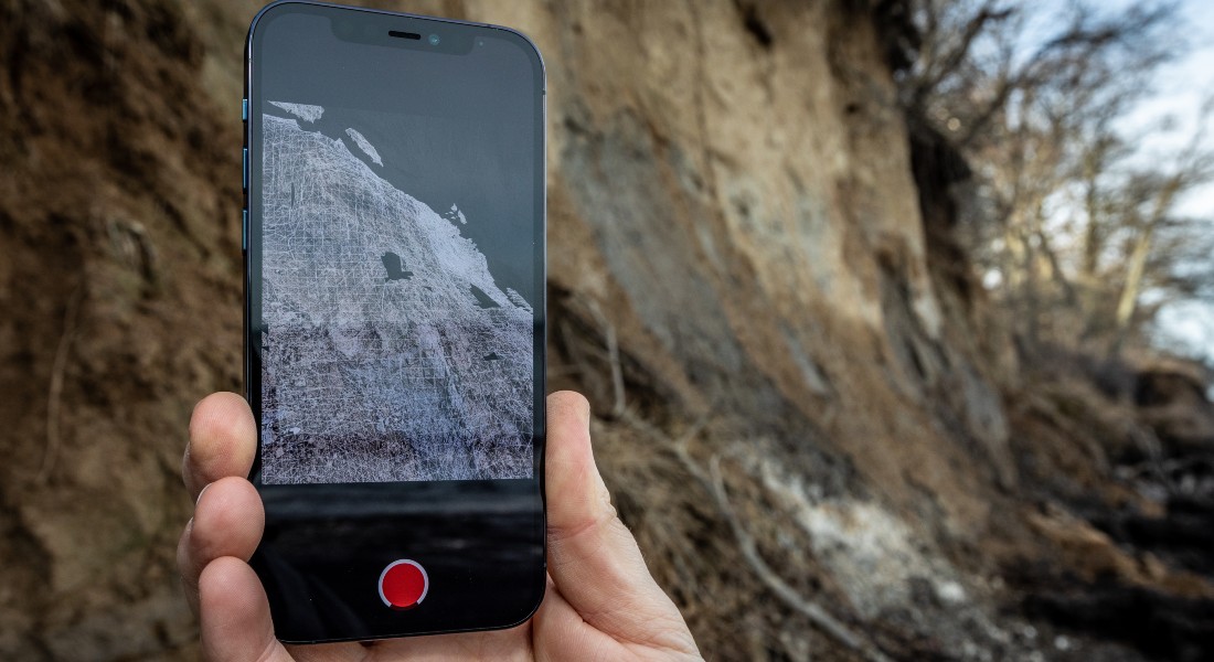
Local monitoring can now be accomplished using a setup that is as basic as an iPhone, selfie-stick and an app. Newer iPhones are equipped with a so-called LiDAR scanner, located on the back of the phone alongside the camera lenses.
"For tech manufacturers, the LiDAR scanner is used to improve a camera's autofocus, but for me and my research team, it is a simple, inexpensive and far less resource-intensive way to measure coastal erosion. In the future, this will allow more people to help with monitoring," explains PhD Gregor Luetzenburg from the University of Copenhagen’s Department of Geosciences and Natural Resource Management.
Citizen scientists can help monitor
LiDAR is an acronym for light detection and ranging. The phone-based 3D scanner emits 576 laser pulses in all directions, making it possible to measure depths in, among other things, a landscape.
According to Luetzenburg, the new scanning method has great potential for more thorough coastal monitoring. This is particularly true if those living in vulnerable areas can be motivated to participate in citizen science.
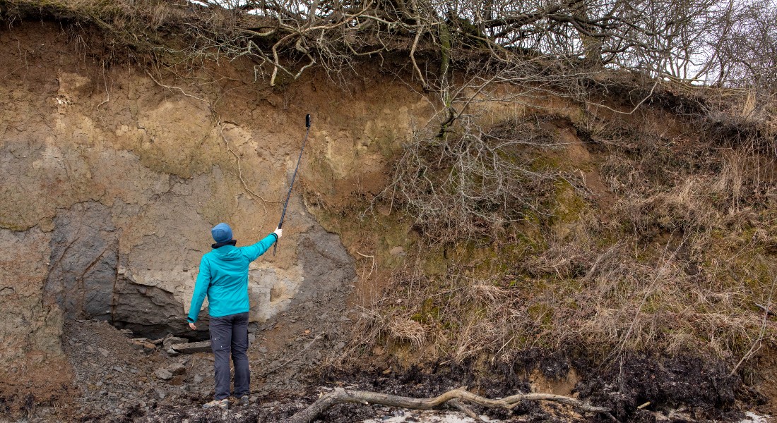
"It's a bit like recording a video with the phone. So, if you are someone who regularly walks your dog along one of these stretches of disappearing coastline, it is obvious that you, together with other citizens around the country, could help researchers and government agencies with the important task of coastal monitoring," says Gregor Luetzenburg, who has just returned from field research in Greenland.
While in Greenland, he developed a guide for geography students how to use the LiDAR scanner to measure the rocky arctic landscape. According to Luetzenburg, something similar could be designed for citizen scientists.
However, if people are to help monitor the Danish coast, an IT platform will have to be created through which videos can be easily submitted. This, says the researcher, shouldn’t be too much of a challenge in our thoroughly digitized society.
Method tested at Rone Klint
Gregor Luetzenburg's ongoing PhD project combines the iPhone’s LiDAR scanner data with geological data, as well as knowledge about precipitation and wind, to learn more about the factors that impact coastlines.
He has conducted a thorough test of the LiDAR method by measuring 1500 square meters of Rone Klint, about an hour’s drive south of Copenhagen.
"The soil at Rone Klint is sandy and formed by glaciers during the last ice age, which makes it quick to erode. A single storm can reshape the entire cliff surface. If you own farmland or a dwelling is just behind the cliff’s edge, it's important to have an idea of how long it will take for the sea to erode your property," says Luetzenburg.
Facts
- The west coast of Denmark suffers from ongoing erosion. Wave action, winds and currents result in constant erosion, while less sediment is transported towards the coast than is transported away from it.
- Storms generate acute erosion, where the impact of waves washes sand away from the shoreline and coastal cliffs.
- LiDAR is an acronym for light detection and ranging. The 3D scanner emits 576 laser pulses in all directions, which makes it possible to measure depths in, among other things, a landscape.
- The technology is very useful for researchers and others to measure how much sand has been eroded from a cliff in the wake of a storm.
- Today, the most common coastal monitoring technique deploys satellite data, which can only capture 2D observations.
- Obtaining more detailed insight into coastal erosion requires large and relatively expensive devices known as terrestrial lasers. However, these instruments are difficult to handle and not very common.
Contact
Gregor Luetzenburg
PhD
Department of Geosciences and Natural Resource Management
University of Copenhagen
+45 35 33 53 88
gl@ign.ku.dk
Michael Skov Jensen
Journalist and team coordinator
The Faculty of Science
University of Copenhagen
+ 45 93 56 58 97
msj@science.ku.dk